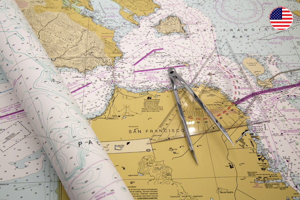
Nautical charts for the USA and Canada – print on demand at HanseNautic
Eckernförde. HanseNautic, Germany’s largest nautical chart distributor, now also offers the official nautical charts of the USA and Canada. These are always printed in the most current version in Eckernförde and distributed to customers worldwide. Modern waterproof paper is used on which everything is clearly readable even after a surge of seawater.
It has never been easier to cross the Atlantic on your own boat. GPS enables secure positioning, satellite monitoring improves weather forecasts and, thanks to modern means of communication, you are not completely alone when problems arise. In addition to the Caribbean beaches, the US and Canadian coasts have also become attractive destinations for cruising sailors. HanseNautic recently received permission to distribute the official NOAA (National Oceanic and Atmospheric Administration) charts for the United States and the Canadian Hydrographic Service as print-on-demand. These charts are also suitable for anyone who wants to charter a boat in US or Canadian waters.
Nautical charts as up-to-date as possible
Whether Florida, Northwest Passage or California: A skipper can only really rely on up-to-date nautical charts. Navigation aids and traffic separation schemes can change and should be correctly identified day and night. River estuaries and coasts are dynamic systems. And Canada’s Arctic passages are only just being re-surveyed because the old data is unreliable and incomplete. HanseNautic always receives the latest versions of the official nautical charts of the USA and Canada. Thanks to print-on-demand, they are as up-to-date as possible. US and Canadian charts printed by HanseNautic are fully compliant with SOLAS regulations. The nautical charts are usually produced and shipped on the same day as the order is placed.
From the Caribbean to the Arctic
The catalogues of the USA and Canada charts can be browsed on the HanseNautic website and cover all national coastal and inland waters of each country. Among them are busy areas like the US Atlantic coast and the Intracoastal Waterway and areas as remote as Alaska and the Northwest Passage, the sea route north of the American continent. The US islands in the Caribbean and the Pacific are also part of it. The offer includes long distance charts as well as coastal charts, approach routes and harbour plans. They have the format Din A0.
Nautical charts on paper are safety equipment
Many skippers today like to use electronic charts. And those who rely on it alone will have a problem if the technology breaks or if there is no electricity. In addition, small monitors often make planning difficult. Paper charts from HanseNautic can be used under all conditions. They are printed in-house on waterproof paper. Even after a long seawater submersion it is enough to simply wipe them dry. Up-to-date paper charts are an indispensable part of safety on board – whether as a main navigation tool or as a back-up.
About HanseNautic
HanseNautic is Germany’s largest supplier of nautical charts, chart folios and nautical literature of all kinds. They are distributed via the online shop and a store based in Eckernförde. The paper and electronic nautical charts cover all the world’s trade lanes. The sources include the Federal Maritime and Hydrographic Agency of Germany, the British Admiralty and other domestic and foreign manufacturers. Navigation literature, training material for sport boat licences and safety equipment are also available. HanseNautic belongs to the NV Chart Group GmbH.
Links:
www.hansenautic.de/amtliche-kanadische-seekarten www.hansenautic.de/amtliche-seekarten-usa-noaa
Contact
HanseNautic / NV Chart Group GmbH
Mr. Sören Zopf
Carlshoehe 75 24340 Eckernfoerde / Germany
phone: +49 4351/469995-0
E-mail: info@hansenautic.de
www.hansenautic.de